Olivia
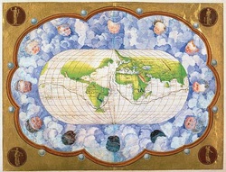
In the Age of Discovery, European pride in its nautical accomplishments blossomed. Commissioned by the Holy Roman Emperor Charles V, the eminent Genoese cartographer, Battista Agnese, celebrated the first known circumnavigation of the Earth via the production of an atlas (“Map of the World, 1540”). A gift for King Philip II of Spain, son of Charles V, the atlas extols Spanish success (“Map of the World, 1540”). Unifying the West’s rapidly evolving awareness of the geographical world with an electrifying depiction of power, pride, and prestige, Agnese’s “World Map” realizes the two motivations of the Emperor. Agnese effortlessly melded the descriptive form and political function of the work into a single “World Map.”
A surprisingly accurate portrayal of the world’s landmasses, Battista Agnese’s map is reminiscent of portolan charts (Miller). These portolan charts emphasize the shorelines of continents rather than the interior landmasses, facilitating their applicability to trade (Miller). The cartographer utilizes lines of latitude and longitude too in order to ensure accuracy. Agnese outlines the paths of both the Spanish silver fleet and Magellan’s crew in gold and black ink respectively (“Map of the World, 1540”). The original purpose of the work remains uncompromised as a clear map holds central focus.
It is important, though, not to discount Battista Agnese’s skill as an artist. Cartographers of the time held the responsibility of glorifying the subject matter via elaborate depictions. The ornate embellishment of the map communicates the prestige of the discoveries. The gold framing encapsulates the image in an aura of brilliance. Within this golden border are four coats of arms, associating the lands with the four imperial patrons (Miller). But perhaps most intriguing is the inclusion of soft blue clouds, perhaps a representation of the heavens. The angelic cherubs that occupy these clouds evoke the Christian God as they blow the voyagers on their way, and, given that the Holy Roman Emperor commissioned the work, a religious undercurrent appears present. Artistically, Agnese succeeds in magnifying the discovery and drawing attention toward the greater powers, both aristocratic and religious, that claimed these new lands.
Cartography of the mid-16th century successfully combines expressive form and political function. Battista Agnese assumes responsibility for both the accurate representation of the known world and the artistic desires of his patrons. By harmonizing such specifications, Agnese produced a product that exhibits the priorities of the Age of Discovery.
Works Cited
“Map of the World, 1540.” John Carter Brown Library. n.d. 18 Sept. 2012. <http://www.brown.edu/Facilities/John_Carter_Brown_Library/maps/content64.html>.
Miller, Angela, et al. American Encounters: Art, History, and Cultural Identity. London: Prentice Hall, 2008. 29.
Image Cited
“Map of the World, 1540.” John Carter Brown Library. n.d. 18 Sept. 2012. <http://www.brown.edu/Facilities/John_Carter_Brown_Library/maps/content64.html>.
 RSS Feed
